European Upper Palaeolithic glaciation, illustration
Bildnummer 12987300
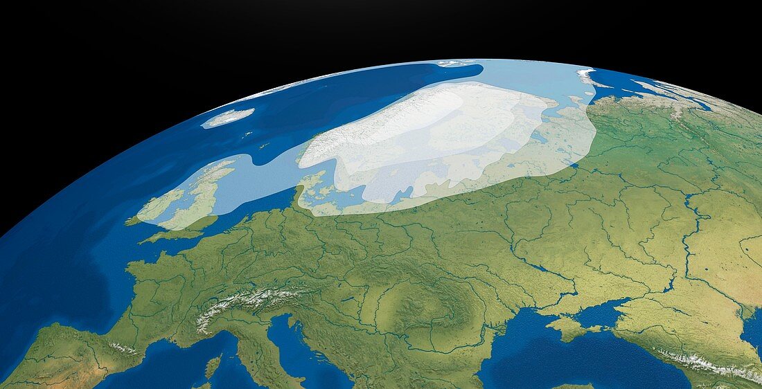
| European Upper Palaeolithic glaciation. Illustration showing the maximum extent of the ice sheets and glaciers at the peak of the last Ice Age, between 20, 000 and 18, 000 years ago. The areas of land and sea covered by the ice include parts of the Atlantic Ocean and the North Sea and Baltic Sea, Greenland, Iceland, the British Isles, Scandinavia, and parts of Northern Europe. | |
| Lizenzart: | Lizenzpflichtig |
| Credit: | Science Photo Library / Jensen, Mikkel Juul |
| Bildgröße: | 8269 px × 4227 px |
| Modell-Rechte: | nicht erforderlich |
| Eigentums-Rechte: | nicht erforderlich |
| Restrictions: | - |
Preise für dieses Bild ab 15 €
Universitäten & Organisationen
(Informationsmaterial Digital, Informationsmaterial Print, Lehrmaterial Digital etc.)
ab 15 €
Redaktionell
(Bücher, Bücher: Sach- und Fachliteratur, Digitale Medien (redaktionell) etc.)
ab 30 €
Werbung
(Anzeigen, Aussenwerbung, Digitale Medien, Fernsehwerbung, Karten, Werbemittel, Zeitschriften etc.)
ab 55 €
Handelsprodukte
(bedruckte Textilie, Kalender, Postkarte, Grußkarte, Verpackung etc.)
ab 75 €
Pauschalpreise
Rechtepakete für die unbeschränkte Bildnutzung in Print oder Online
ab 495 €
Keywords
- 1,
- Atlantisch,
- Berg,
- Berge,
- Eis,
- Eisdecke,
- Eiszeit,
- Erde,
- Erdkunde,
- Europa,
- europäisch,
- Fluss,
- Flüsse,
- geografisch,
- Geographie,
- Geologie,
- geologisch,
- Glaziologie,
- Gletscher,
- Illustration,
- Insel,
- Inseln,
- Klimatologie,
- klimatologisch,
- Kontinent,
- Kunstwerk,
- Küsten,
- Küsten-,
- Küstenlinie,
- Land,
- maximal,
- Meer,
- Niemand,
- Ozean,
- Ozeane,
- Paläolithiker,
- prähistorisch,
- Reihenfolge,
- Schnee,
- schwarzer Hintergrund,
- Serie,
- Skandinavisch,
- topografisch,
- Topographie,
- topographisch,
- Vegetation,
- Vorgeschichte,
- Wasser