Hurricane Isabel,15th September 2003
Bildnummer 11737989
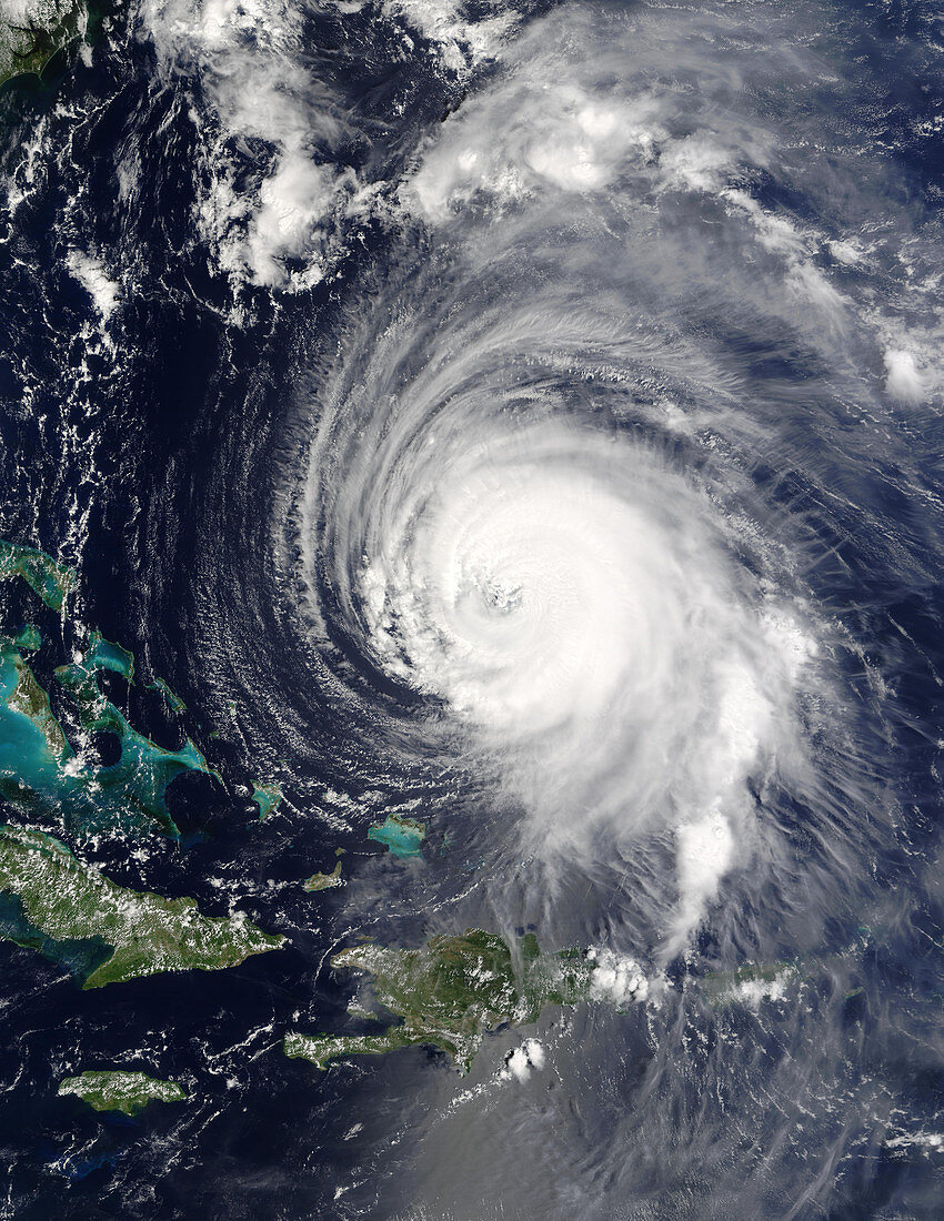
| Hurricane Isabel in the Caribbean Sea on 15th September 2003. The islands of Hispaniola (lower centre) and the eastern tip of Cuba (lower left) are seen,along with the shallow seas (green) around the Bahamas. The US state of Florida is just out of frame at top left. Isabel was classified as a type 5 hurricane,the strongest,but was downgraded to a type 4 on 16th September. Hurricanes are enormous rotating storm systems in which winds can reach over 240 kilometres per hour. They can cause immense damage if they hit built-up areas,but lose energy quickly once over land. This image was taken by the MODIS instrument on the Terra satellite | |
| Lizenzart: | Lizenzpflichtig |
| Credit: | Science Photo Library / NASA |
| Bildgröße: | 3500 px × 4529 px |
| Modell-Rechte: | nicht erforderlich |
| Eigentums-Rechte: | nicht erforderlich |
| Restrictions: | - |
Preise für dieses Bild ab 15 €
Universitäten & Organisationen
(Informationsmaterial Digital, Informationsmaterial Print, Lehrmaterial Digital etc.)
ab 15 €
Redaktionell
(Bücher, Bücher: Sach- und Fachliteratur, Digitale Medien (redaktionell) etc.)
ab 30 €
Werbung
(Anzeigen, Aussenwerbung, Digitale Medien, Fernsehwerbung, Karten, Werbemittel, Zeitschriften etc.)
ab 55 €
Handelsprodukte
(bedruckte Textilie, Kalender, Postkarte, Grußkarte, Verpackung etc.)
ab 75 €
Pauschalpreise
Rechtepakete für die unbeschränkte Bildnutzung in Print oder Online
ab 495 €
Keywords
- Atlantischer Ozean,
- Auge,
- Bahamas,
- Erdbeobachtung,
- extrem,
- Hurrikan,
- Inseln,
- Isabel,
- Karibisches Meer,
- Klima,
- Kuba,
- Meteorologie,
- meteorologisch,
- modis,
- Satellit,
- Spiral,
- Spirale,
- spiralförmig,
- stark,
- Sturm,
- Stürme,
- System,
- Terra,
- Warnung,
- Wetter,
- Wind,
- Windig,
- Wolke,
- Wolken