Portugal and Spain
Bildnummer 11736088
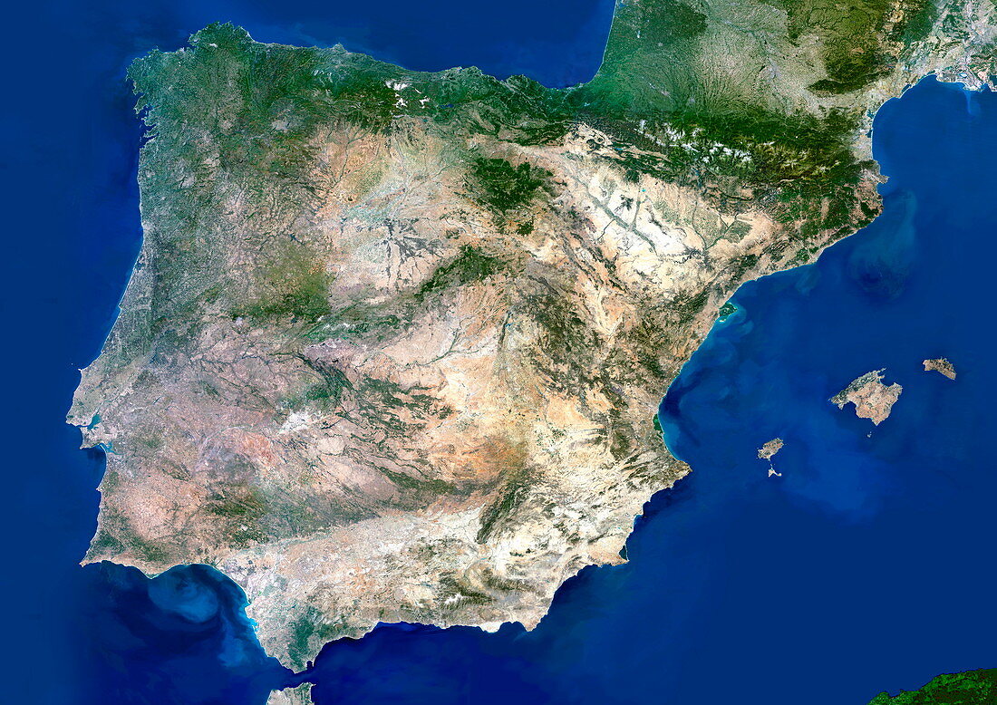
| Portugal and Spain. Satellite image of the Iberian Peninsula,consisting of the European countries of Portugal and Spain. North is at top. Water is blue,vegetation is green,urban areas are grey,dry areas are brown,and shallow coastal waters are light blue. The area here is about 1375 by 975 kilometres. Portugal is a 200-kilometre wide strip along most of the western (Atlantic) coast (left). Most of Spain's Atlantic coast is at upper left,and its Mediterranean coast is at right. The Spanish Balearic islands are at centre right. The Pyrenees mountains (upper right) form the border with France. Spain is dominated by a high,dusty central plateau (brown). The Straits of Gibraltar (bottom left) divide Spain from Morocco | |
| Lizenzart: | Lizenzpflichtig |
| Credit: | Science Photo Library / Planetobserver |
| Bildgröße: | 4961 px × 3508 px |
| Modell-Rechte: | nicht erforderlich |
| Eigentums-Rechte: | nicht erforderlich |
| Restrictions: | - |
Preise für dieses Bild ab 15 €
Universitäten & Organisationen
(Informationsmaterial Digital, Informationsmaterial Print, Lehrmaterial Digital etc.)
ab 15 €
Redaktionell
(Bücher, Bücher: Sach- und Fachliteratur, Digitale Medien (redaktionell) etc.)
ab 30 €
Werbung
(Anzeigen, Aussenwerbung, Digitale Medien, Fernsehwerbung, Karten, Werbemittel, Zeitschriften etc.)
ab 55 €
Handelsprodukte
(bedruckte Textilie, Kalender, Postkarte, Grußkarte, Verpackung etc.)
ab 75 €
Pauschalpreise
Rechtepakete für die unbeschränkte Bildnutzung in Print oder Online
ab 495 €
Keywords
- Atlantisch,
- Balearen,
- balearisch,
- Erdbeobachtung,
- Europa,
- europäisch,
- geografisch,
- Geographie,
- Iberische Halbinsel,
- Insel,
- Inseln,
- Küste,
- Küstenlinie,
- Land,
- Meer,
- Mittelmeer,
- Nation,
- Ozean,
- Plateau,
- Portugal,
- Portugiesisch,
- Satellit,
- Satellitenbild,
- Spanien,
- spanisch,
- Staubig,
- trocken,
- Wasser,
- Weltall