Great Siege of Malta,1565
Bildnummer 12959997
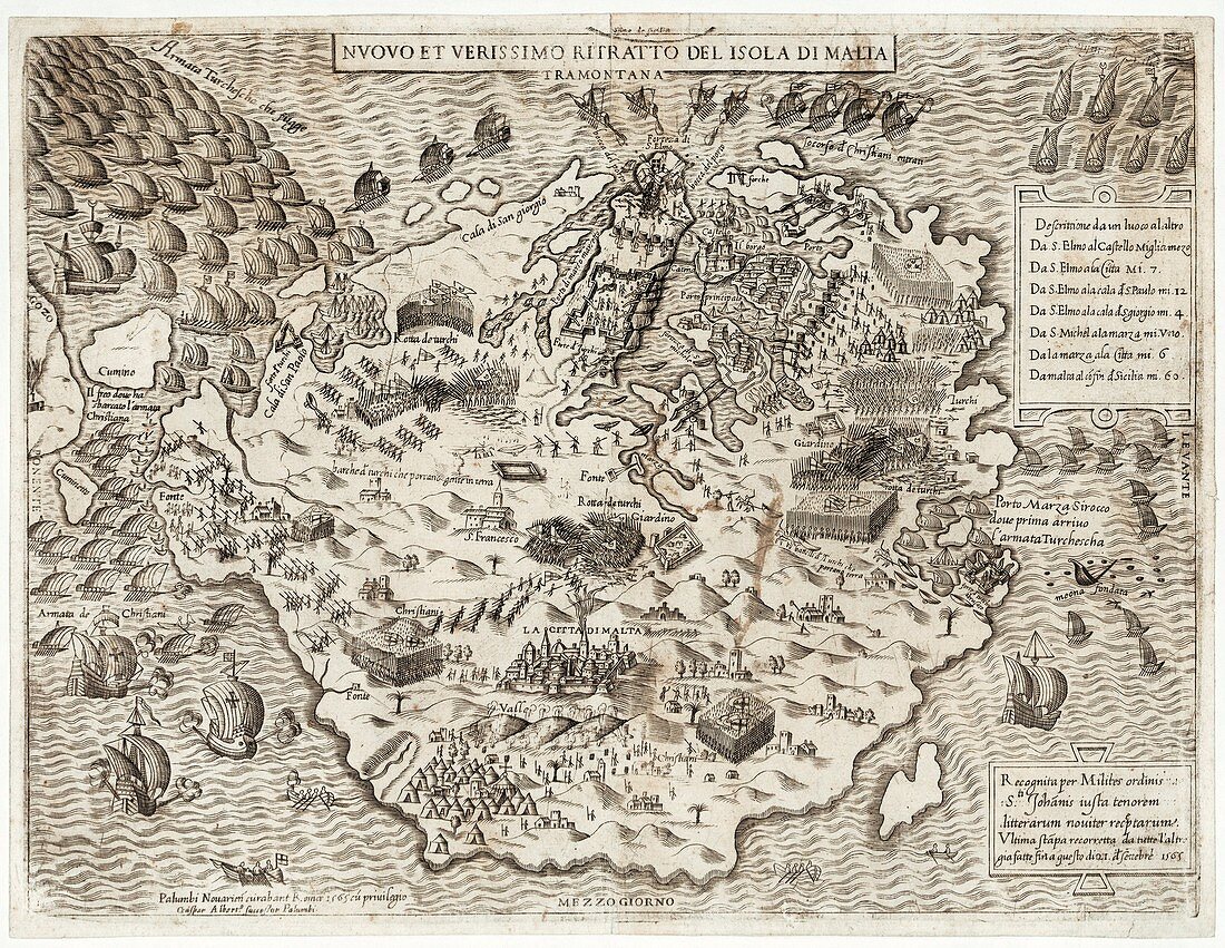
| Great Siege of Malta,1565. The map shows the ships of a Christian relief armada (lower left) and the Turkish fleet of the Ottoman Empire (upper left),with troops of Crusader Knights defending the island of Malta itself. The main port and harbour is at upper centre. The military Order of Saint John (the Knights Hospitaller) is mentioned at bottom right,with key battles listed at upper right. During this siege,the Ottoman Empire tried to invade Malta,but the Knights Hospitaller successfully defended the island,a key point in the defence of Europe and Christendom from the Ottomans. This map is from 'Geografia tavole moderne di geografia' (1575) by Antonio Lafreri,Paolo Forlani and Giacomo Gastaldi. | |
| Lizenzart: | Lizenzpflichtig |
| Credit: | Science Photo Library / Library of Congress,Geography and Map Division |
| Bildgröße: | 4771 px × 3691 px |
| Modell-Rechte: | nicht erforderlich |
| Eigentums-Rechte: | nicht erforderlich |
| Restrictions: | - |
Preise für dieses Bild ab 15 €
Universitäten & Organisationen
(Informationsmaterial Digital, Informationsmaterial Print, Lehrmaterial Digital etc.)
ab 15 €
Redaktionell
(Bücher, Bücher: Sach- und Fachliteratur, Digitale Medien (redaktionell) etc.)
ab 30 €
Werbung
(Anzeigen, Aussenwerbung, Digitale Medien, Fernsehwerbung, Karten, Werbemittel, Zeitschriften etc.)
ab 55 €
Handelsprodukte
(bedruckte Textilie, Kalender, Postkarte, Grußkarte, Verpackung etc.)
ab 75 €
Pauschalpreise
Rechtepakete für die unbeschränkte Bildnutzung in Print oder Online
ab 495 €
Keywords
- 1500er Jahre,
- 16. Jahrhundert,
- Armada,
- Belagerung,
- christlich,
- Einfarbig,
- Europa,
- europäisch,
- gedruckter Text,
- geografisch,
- Geographie,
- Geschichte,
- historisch,
- Insel,
- islamisch,
- kämpfen,
- Karte,
- Kartographie,
- Krieg,
- Kriegsführung,
- Malta,
- Militär-,
- Mittelmeer,
- Niemand,
- Osmanisches Reich,
- Schiffe,
- Schlacht,
- Schwarz und weiß,
- Türkisch,
- Verteidigung